
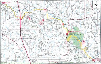
Trip Overview
Black Creek Trail is a 41 mile trail along Black Creek in De Soto National Forest. The trail passes through Black Creek Wilderness Area, which according to the guy that shuttled me to the start, was specifically created to prevent Camp Shelby from encroaching on any more forested land. I could not confirm this claim, but it makes a good backdrop for my trip since it felt like a warzone during certain portions. My hike started at Fairley Landing and ended at Big Creek Landing. There wasn't much elevation change to worry about, and numerous highlights could be found along Black Creek (bend before Hickory Creek, near Beaverdam Creek, Moody's Landing) and in Black Creek Wilderness Area, which was very serene. No permits or fees are required to use the trail, and camping is allowed anywhere along the Creek side of the trail. I completed the hike in two days in the beginning of February 2018.
Preparation
I feel like I should discuss my preparation a little because this was my first backpacking trip. I'm an avid marathon and trail runner, but I recently decided that I may have peaked in my running training. I've qualified for Boston four times now, and I'd still like to get a sub 3 marathon but my thrill for training has dwindled and will likely die soon. It has always been a dream of mine to hike the Appalachian with my dog, so I decided to start backpacking to see if I can work toward realizing that dream before Penny gets too old. I was also partially inspired by my recent reading of Wild by Cheryl Strayed.
Before this January, my only experience with backpacking was very basic day hikes, for which I threw packs together with random items I already owned. It should go without saying that I have virtually no personal experience with legitimate backpacking, and I relied heavily on online resources to prepare for my trip. Reddit was excellent for getting a general idea of the gear I'd need, and I purchased most of the equipment from Amazon. My gear list is marked to show the items I plan to upgrade/replace and items I plan to remove.

My general goal when building my kit was to keep the weight under 40 pounds. I actually have no idea how I picked 40, and it was definitely a mistake not to do additional research about a target weight for my pack. I picked individual items by searching Amazon and purchasing whatever had the lowest weight with a reasonable price (tried to keep it under $40) and rating. I already had some old trail running shoes that I decided would be good enough, and this was my second significant mistake.
 |
| Great ventilation for air and water! |
 |
| Insoles to crush the soul. |
I had perhaps too much confidence in my personal fitness and toughness when planning. I also felt that Black Creek Trail was relatively safe because (1) the Creek makes it difficult to get lost and (2) there are so many roads that intersect the trail. It would have benefited me to take things much more seriously when planning, but ultimately, I feel that I successfully completed the trail without taking any significant risks so my assessment was probably mostly correct.
My food was pretty standard fair:
- Breakfast
- Quaker High Protein Oatmeal
- Kind Bars
- Coffee
- Lunch
- Tortillas
- Peanut Butter
- Jerky
- Clif Builder Bars
- Dinner
- Knorr Sides
- Reese's Peanut Butter Bar
- Dog
- Dog food
- Pizzle Sticks
Also, a huge shout-out to Chase Tucker for his instructional video on trekking poles. Had I not watched this video the night before my hike, I am confident that I would not have finished in two days. With my pack as heavy as it was, my poles were the only thing keeping me going for a good portion of the second day. About five miles into the hike, I started to feel like Dr. Octopus when going down hill or crossing streams via logs.
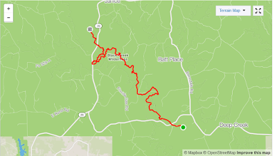
The coolest bit of prep I did was to convert a paper trail of the map to the GPX file linked above. Basically, I used QGIS to georeference an image of the paper map, and then I hand-traced the trail to generate a GPX file that I could load onto my Garmin watch. Using dwmap on my watch during the hike was very nice because it allowed me to always have a map of the trail on hand and to monitor my position in real-time. I plan to do a tutorial on how to create a GPX file as described above some time in the future.
Weather
The forecast for Thursday, 2/8, was 40-60° F and sunny, for Friday was 40-60° F with a slight chance of rain, and for Saturday 40-60 with a high chance of Thunderstorms. The reason I pushed so hard to finish in two days was to avoid having to sleep in my SHITTY Ozark tent during a thunderstorm. Also, it rained the three days before the start of my trip. I probably should have waited a week to do my hike because the grounds were still really wet, but I was impatient from all the planning and raring to go. I'd recommend planning for wet conditions because much of the trail is low-lying and prone to flooding. My socks were soaked for the entire second day, and I wish I would have planned better to somehow keep my feet dry and/or blister free.
Difficulty
Most of the trail is pretty well blazed, but I found it easy to go off trail because portions of it follow old log roads that are easy to get side-tracked on if you are in the zone. Almost the entire trail is what I would consider to be moderate to easy difficulty, so I was glad that I at least had picked a relatively easy trail for my first thru-hike.
Transportation
If you need a shuttle from the end to the start of the trail, Black Creek Canoe Rental charges $60 to shuttle as many people as can fit in a van, and Brandon was very helpful and knowledgeable about the trail. I called a couple times before my trip to get updates on the condition of the trail. Brandon recommended I start at Fairley Bridge Landing because it is the more technical side of the trail, and I'm glad I followed his advice because the second day was hard enough without having to deal with the tougher portion of the trail.
The Hike - Day 1
I was dropped off by the shuttle at Fairley Bridge around 9:30 a.m., and on the trail about 15 minutes later. About two miles in at a utility clearing, I ran into a hunter that appeared to have missed the memo about primitive hunting season, but he was a nice enough guy. He wasn't having any luck finding deer, and I hadn't seen any large animals that morning at all. After that the hiking was pretty uneventful, and then I stopped at mile 4.7.

Portions of the morning hike were pretty rough because they're were a lot of low spots with the water that got my feet wet. Thankfully, the trail cleared up around mile 3 and things stayed relatively dry for the rest of the day.
 |
| A little break at the beach |
At around mile 5.4 I fell flat on my ass while trying to cross a bridge, but I lucked out and only scuffed my palm and bruised my right arm. A little while after my fall, I ran into another hunter who was pulling a decoy out of the woods. The second hunter was also very nice and seem to be appreciating the good weather as well. Then I tried to tune in as much as possible to get some good miles in before lunch. Unfortunately, the soles of my shoes were a little worn out, so by the time I stopped for lunch, I was pretty close to developing some blisters.
 |
| Puppies were barking |
 |
| Black Creek Wilderness |
I switched to my second pair of socks during lunch. The only other incident of note during the morning was around mile 7 where there was a log bridge with a rope hold that was difficult to cross. I almost fell off while crossing because the rope wasn't very taunt. I was worried about Penny being able to cross the log, but she strolled across like she was taking a walk in the park and look puzzled at my difficulty. Throughout the morning, I kept a very good pace of 2.5 mph so was about 10 miles in after four hours. I hoped to get in another 10 miles before sunset; however, things did not go according to plan.
Afternoon
At around 12.5 miles, I went off trail a bit because I followed some old markers that took me through the rough. Then I made the supremely stupid decision to take a shortcut that was off trail at around mile 13. I thought I could cut off part of the big loop that goes down and around Beaverdam Creek because I saw what I thought was a dried up creekbed. It was actually a dried up branch of Beaverdam, and I ended up offtrail on the shore of Beaverdam with no way to cross. I decided to just follow the Creek rather than double back, and while the going was rough, I made it down to Highway 29 without too much trouble. I think I did end up cutting off a little bit of the loop, but it wasn't worth the trouble of fighting through the rough.
I was still well short of my goal of 20 miles, so I decided I would keep hiking into the night.
 |
| Penny is getting a little tired of my shit |
My legs were getting very tired at this point though, and I was down to my last liter of water. I decided to forge on until I found a nice stream with a good campsite nearby. I passed up one stream because I thought I could find better and later regretted not stopping to at least collect some water. The next stream wasn't for about another 2 or 3 miles, and by then I was dead tired and ready for some sleep.
Penny was not helpful when setting up camp. As soon as I laid down the tent, she thought I was done and immediately laid on the tent to go to sleep.

I wrestled with her and the tent for a while to do a half-assed job and then settled in for the night. Dinner went off without a hitch, and the Knorr Taco Rice side were way tastier than expected. My SHITTY Ozark tent was so crowded between my kit, Penny, and myself, and I set my tent up in the wrong direction so had to sleep in the short end to keep my head uphill. My shoulder was touching the sagging roof most of the night, and there was a lot of condensation and cold coming through onto my face. Thankfully, I was tired as hell and able to get a good 6-7 hours of sleep anyway.
The Hike - Day 2

All night I could hear babbling water all around me, but I didn't fully appreciate my campsite until morning of Day 2. I had setup camp on a bluff that was almost completely surrounded by stream water.

It is difficult to see in the picture, but it was a very nice spot to soak in the wilderness. Penny still wasn't happy in the morning and continued to give me plenty of sass.

After coffee and one of the most primal shits I have ever taken, I was feeling somewhat recovered and ready to take on the trail again. My phone signal (AT&T) was very spotty the first day, but it started coming in strong mid-morning and stayed with me for the rest of the trip.
My goal for Day 2 was to to finish the trail if possible because the forecast for tonight and tomorrow called for thunderstorms, and I did not trust my SHITTY Ozark tent. I was somewhat confident because I was starting Day 2 about two hours earlier than Day 1.
 |
| Nice spot I found about 2 hours in |
Miles 6-13 of Day 2 were near Ashe Lake Range and not too far from Camp Shelby, which resulted in a lovely orchestra of gunfire for much of the day. In general, the morning miles cruised by until I went off trail again because I was auto-piloting down a log road. I decided to stick with my practice of never turning back and planned a four mile route along dirt roads and highways to get me back on the trail South of Brooklyn. The log roads were actually quite nice to hike because there were still plenty of trees; however, New York Road was a bit of a bore so I listened to Iron Gold to pass the time.
“Look into yourself, Darrow, and you’ll realize that you are a good man who will have to do bad things."....
“See. That’s what I don’t get. If I am a good man, then why do I want to do bad things?”
― Pierce Brown, Red Rising
I'll spare you the details of the last six miles of my journey, but to summarize, it fucking sucked. Shoes wet, blisters throbbing, darkness encroaching, sanity leaving, FML... When I was about half a mile away, I even jogged for a few hundred yards in a delirious attempt to end the suffering. The sight of my car was perhaps the most beautiful hunk of metal I had ever laid eyes on. Even Penny who gets severely carsick was happy to climb in and find comfort in its familiar interior.
Epilogue
In my post hike high, I decided to drive immediately to Arby's and eat whatever struck my fancy. After consuming a medium Jamocha shake, curly fries, three buffalo chicken tenders, a Reuben sandwich, and my self-respect, I drove home in a bloated stupor. Penny and I conquered Black Creek Trail, and despite all the pain, it felt great.
 |
| I don't know what the big deal is... that was pretty damn easy |
* Edit - removed my endnote because in retrospect, I was being overly sensitive and out of line.


No comments:
Post a Comment